LA to San Diego on the scoot...
Moderator: Modern Buddy Staff
-
JoshInLA
- Member
- Posts: 23
- Joined: Sun Feb 14, 2010 8:51 pm
- Location: LA
LA to San Diego on the scoot...
Hi- I've had my buddy for about six weeks, and have about 825 miles on her. I'm going to San Diego this weekend, and was curious if anyone had any advice?? This will be by far the longest trip I have taken on the scoot. Also if anyone has done this specific trip before, maybe route suggestions? From the westside of LA to downtown SD. Thanks.
-
Skootz Kabootz

- Member
- Posts: 4305
- Joined: Sat Nov 15, 2008 12:47 pm
- Location: West Hollywood, CA
- Contact:
Congrats on your new Buddy! As mentioned, from LA to SD there is a stretch where unless you can get a pass onto/through Camp Pendelton, you have no choice but to take the highway (you can take a massive inland detour but it really is quite massive). I've been wanting to do this ride for ages but have yet to find a way through the Base.

-
ericalm

- Site Admin
- Posts: 16842
- Joined: Sat Jun 10, 2006 3:01 am
- Location: Los Angeles, CA
- Contact:
You can get a pass to go through Pendleton but they require boots and a military-spec reflective vest.
Info and contacts here: http://www.pendleton.usmc.mil/informati ... access.asp
You may want to call; I've heard of people just riding up and being allowed through.
There's also the eastern route around the base, but you'll be in for a very long and trying ride going this way.
Info and contacts here: http://www.pendleton.usmc.mil/informati ... access.asp
You may want to call; I've heard of people just riding up and being allowed through.
There's also the eastern route around the base, but you'll be in for a very long and trying ride going this way.
Eric // LA Scooter Meetup Group // Stella 4T // Vespa LX // Vespa LXS // Honda Helix // some, uh, projects…
-
Skootz Kabootz
- Member
- Posts: 4305
- Joined: Sat Nov 15, 2008 12:47 pm
- Location: West Hollywood, CA
- Contact:
Great to know! You certainly are a vast reservoir of information Ericericalm wrote:You can get a pass to go through Pendleton but they require boots and a military-spec reflective vest.
Info and contacts here: http://www.pendleton.usmc.mil/informati ... access.asp
You may want to call; I've heard of people just riding up and being allowed through.
There's also the eastern route around the base, but you'll be in for a very long and trying ride going this way.
-
Lostmycage

- FAQ Moderator
- Posts: 4062
- Joined: Tue Jun 17, 2008 3:36 am
- Location: The Interwebz!
You need this:
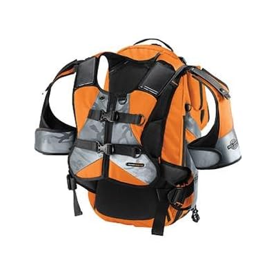
It's an Icon Mil Spec Backpack.
It's approved for use on military bases and it holds a lot and has built in compression straps. I actually used it as my laptop/electronic, raingear, snack and paperwork bag when I went on vacation last fall. I wasn't on the bike or near any military bases, but no one missed me coming and no one could have taken it unnoticed, lol. It's a lot of bag and very purpose built. If you actually use the helmet compartment and strap your jacket to it, you'll look like a pack mule. A bright orange pack mule.
Check out  Scoot Richmond's new site: My awesome local shop.
-
JoshInLA
- Member
- Posts: 23
- Joined: Sun Feb 14, 2010 8:51 pm
- Location: LA
-
jijifer
- Member
- Posts: 1450
- Joined: Mon Mar 30, 2009 4:18 pm
- Location: San Diego
I've been wanting to do the reverse ride and me and N2Tattoos road to the South Gate at Pendleton to inquire. First, the 18yr olds watching the gate kept giggling at our "mopeds" They told us that we needed full gear, reflective vest, proof of passing MSF and even then, without a sponsor, it was up to whomever was watching the gate when we arrived.
Getting a sponsor is as easy as knowing ANYONE with permission to be on base and having them get a pass. It would be an easy peasey ride then. And showing up is always better than over the phone.
But thus far, it's not a ride I've done. The inland ride would be a really neat one but yeah, REALLY long. I wouldn't scoot on that stretch of the I5. It's loads of young military folks driving like they've got nothing to lose (really fast and really reckless). If you could do it in the witching hours like be on that stretch btwn 4-5 am - MAYBE you'd get through with very few knuckleheads on the road. But even then I'd be white knuckled and scared!
-
JoshInLA
- Member
- Posts: 23
- Joined: Sun Feb 14, 2010 8:51 pm
- Location: LA
Thanks for all of your help. You have spared me much wasted time and frustration. I looked into taking the eastern detour, but it adds about 70 miles and 2 hours to the ride, which is something I would actually consider, but that also adds 26 turns. I don't see a way for a new scooterist to safely navigate 26 turns in unknown territory without getting lost, or pulling over every 5 minutes to get the directions out of my pocket. Looks like the cage for me.
For the record, I think this is a really absurd situation.
For the record, I think this is a really absurd situation.

-
rondothemidget
- Member
- Posts: 245
- Joined: Wed Jul 02, 2008 2:36 pm
- Location: Orange County
I've had fun with Google maps and figured out a way to get from LA/OC to Palm Springs. At Cabazon, you could go north a little ways and make it all the way to Arizona.
I wouldn't attempt sneaking on I5 through Camp Pendelton. Most people drive 80-90 in that stretch between San Clemente and Oceanside. Kaos probably has the only Buddy that could keep up at those speeds.
I wouldn't attempt sneaking on I5 through Camp Pendelton. Most people drive 80-90 in that stretch between San Clemente and Oceanside. Kaos probably has the only Buddy that could keep up at those speeds.
-
n2tattoos
- Member
- Posts: 198
- Joined: Sat Jan 10, 2009 4:11 am
- Location: San Diego, CA
rondothemidget wrote:I've had fun with Google maps and figured out a way to get from LA/OC to Palm Springs. At Cabazon, you could go north a little ways and make it all the way to Arizona.
jijifer and i will be heading up to palm springs in about a month. what's the route from palm springs to LA?
totally agree.rondothemidget wrote:I wouldn't attempt sneaking on I5 through Camp Pendelton. Most people drive 80-90 in that stretch between San Clemente and Oceanside. Kaos probably has the only Buddy that could keep up at those speeds.
-
rickko

- Member
- Posts: 626
- Joined: Sun Jul 06, 2008 5:35 am
- Location: Somewhere in the Milky Way
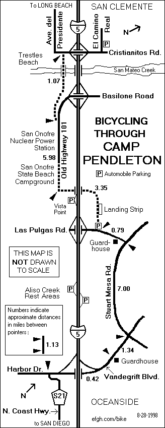
Here's the civilian bicycle route through Pendleton. Maybe someday when driving southbound you might route yourself to the northern guardhouse on Las Pulgas Rd. and ask them their policy since they let bicycles through there. I've ridden the route a couple of times on a bicycle myself years ago.
Generally, if you're going to ride a motorcycle or scooter on a military base they'll want you to have an orange reflective vest, close toed shoes that go above angles, insurance and registration proof, a driver's license and likely a full-face helmet or one with face protection.
I've always found it ironic that you can ride a bicycle on a military base at the same speed you'll go on a m/c or scooter yet you need zero protection but if you're on a motor cycle/scooter you've nearly got to wear body armor.
..rickko..
Ride it like you enjoy it!
MB member #2568
MB member #2568
-
rondothemidget
- Member
- Posts: 245
- Joined: Wed Jul 02, 2008 2:36 pm
- Location: Orange County
n2tattoos wrote:rondothemidget wrote:I've had fun with Google maps and figured out a way to get from LA/OC to Palm Springs. At Cabazon, you could go north a little ways and make it all the way to Arizona.
jijifer and i will be heading up to palm springs in about a month. what's the route from palm springs to LA?
I can send you the link if you PM with your email address. This is from Imperial Highway in OC. I haven't actually taken this route but it seems like the most direct. The only issue is you would be on the 10 freeway for less than a half mile before it turns into the 110 highway.
4. Turn left at S Imperial Hwy
5. Turn right at N Rose Dr - 1.1 mi
6. Take the 3rd right onto CA-142 E/Valencia Ave - 0.4 mi
7. Turn right at CA-142 E/Carbon Canyon Rd - 8.4 mi
8. Turn right at CA-142 E/Chino Hills Pkwy (signs for CA-142/Chino Hills Pkwy) Continue to follow Chino Hills Pkwy - 2.0 mi
9. Turn left at Ramona Ave - 1.0 mi
10. Take the 2nd right onto Edison Ave - 8.5 mi
11. Turn right at Hamner Ave/S Milliken Ave - 0.6 mi
12. Turn left at Bellegrave Ave - 1.3 mi
13. Turn right at Jurupa Rd - 3.1 mi
14. Turn right at Van Buren Blvd - 3.5 mi
15. Turn left at Central Ave - 5.7 mi
16. Continue onto Alessandro Blvd - 0.7 mi
17. Turn left at Chicago Ave - 1.0 mi
18. Turn right at Central Ave - 2.1 mi
19. Slight right toward Sycamore Canyon Blvd - 0.3 mi
20. Continue straight onto Sycamore Canyon Blvd - 0.7 mi
21. Turn left at Fair Isle Dr - 0.1 mi
22. Continue onto Box Springs Rd - 1.4 mi
23. Continue onto Ironwood Ave - 7.1 mi
24. Turn left at Redlands Blvd - 3.3 mi
25. Turn right at San Timoteo Canyon Rd - 10.0 mi
26. Continue onto Oak Valley Pkwy - 3.2 mi
27. Turn right at N Highland Springs Ave - 0.7 mi
28. Take the 1st left onto W Wilson St - 4.5 mi
29. Turn right at N Hargrave St - 0.6 mi
30. Turn left at Johnson Ln - 3.8 mi
31. Turn left at Apache Trail - 33 ft
32. Take the 1st right onto Main St - 1.6 mi
33. Continue onto Railroad Ave - 5.4 mi
34. Turn right to merge onto I-10 E - 0.4 mi
35. Take the State Route 111 exit toward Palm Springs - 0.4 mi
36. Merge onto CA-111 S - 9.4 mi
37. Turn left at W Vista Chino - 364 ft
38. Take the 1st right onto N Indian Canyon Dr - 1.0 mi
39. Turn left at E Alejo Rd - 105 ft
Arrive at: Palm Springs, CA