Hi everyone,
Do you guys have any suggestions on how to map out a good route when taking a long trip. I'm thinking about going from Chicago to Louisville. Obviously I can't take the highway so I'm trying to figure out how to get there. Is google maps (bike route) the best way to figure this out?
Thanks!
Mapping out a long trip
Moderator: Modern Buddy Staff
-
smillerlou
- Member
- Posts: 41
- Joined: Tue May 07, 2013 9:29 pm
- Location: Chicago
-
mer10
- Member
- Posts: 5
- Joined: Fri Aug 23, 2013 4:58 pm
- Location: San Diego
Trip maping
Google maps as an option to avoid highways. This is the best option. Bike rout or walking route can sometimes take you to nature trails. For google maps you click on get directions and then show options. Good luck!
-
PeteH

- Member
- Posts: 2281
- Joined: Mon Jan 17, 2011 4:32 pm
- Location: 3603mi SE of Dutch Harbor
Just as an aside, I'm playing with the CoPilot GPS app (for iOS and Android). Unlike most 'mobile' GPS apps, you can drag a route to change it, as you would in Google Maps. Another slick feature is that you can select various vehicle types (car, RV, motorcycle, bicycle,...) and more importantly, you can tell the software to avoid or strictly-avoid certain types of roads (like Interstates), and you can specify the speed to use on each type of road in order to calculate drive time and choose routing.
If only Google Maps had this granularity of features!
If only Google Maps had this granularity of features!
Feel da rhythm! Feel da rhyme! Get on up! It's Buddy Time!
-
smillerlou
- Member
- Posts: 41
- Joined: Tue May 07, 2013 9:29 pm
- Location: Chicago
-
Dooglas

- Moderator
- Posts: 4368
- Joined: Sun Jul 08, 2007 2:17 am
- Location: Oregon City, OR
-
mer10
- Member
- Posts: 5
- Joined: Fri Aug 23, 2013 4:58 pm
- Location: San Diego
Long trips
O and I always bring extra gas on a trip over 100 miles. I have used the clip under the seat horn to hole a 1gl gas can. This will increase your range a give you a little peace of mind. IF you dont want to take a gas can you can get a MSR camp fuel container and they should fit in the glove box.
-
Rusty J
- Member
- Posts: 109
- Joined: Mon Apr 23, 2012 5:04 pm
- Location: L.A. Beach Cities, CA
If you have an Android tablet in addition to your Android phone, and they both have the same Google ID, you can get another copy of CoPilot for the tablet at no extra cost. (Unfortunately, you have to download the 2 gigs of maps again...) You can then use the larger display of the tablet to create a route, save it, and copy it to your phone.PeteH wrote:Just as an aside, I'm playing with the CoPilot GPS app (for iOS and Android). Unlike most 'mobile' GPS apps, you can drag a route to change it, as you would in Google Maps. Another slick feature is that you can select various vehicle types (car, RV, motorcycle, bicycle,...) and more importantly, you can tell the software to avoid or strictly-avoid certain types of roads (like Interstates), and you can specify the speed to use on each type of road in order to calculate drive time and choose routing.
If only Google Maps had this granularity of features!
Here's how: Connect your tablet to a computer as USB Storage, or use a file manager app, and navigate to the folder on the tablet where CoPilot stores saved routes:
Route files are saved as [routename].trp in /mnt/sdcard/com.alk.copilot.namarket.premiumusa/NA/save
(North America map set; not sure what the directory structure looks like with other map sets.)
Copy the desired route file, and transfer it to the same folder on the phone. You can do this by:
- Dragging it to the desktop (if you're using one) and reversing the process to put it onto the phone
- Attaching the file to an email you send to yourself
- Sending it via bluetooth or wifi direct (if supported)
Note that the latter options will generally put the file in your download folder -- use a file manager app to shift it to the correct location or CoPilot won't see it.
You left out one of the really key features of CoPilot: the maps are stored on the device, and it calculates the route natively -- you don't need a data connection of any sort to get directions, just a GPS fix. This can be really useful out in the boonies!
I'm still testing it out. The things I still need to check are what happens when you close the app, and restart it, while following a saved custom route. I'm pretty sure it'll send you back to the start, even if you've already passed a designated waypoint. The workaround for this is to delete the waypoints you've passed from the saved route before requesting directions. (You might want to keep an unmodified backup copy of the route somewhere and/or save multiple versions of the route, each one starting the route one waypoint further along than the last.)
-
Rusty J
- Member
- Posts: 109
- Joined: Mon Apr 23, 2012 5:04 pm
- Location: L.A. Beach Cities, CA
Testing CoPilot Live
Some quick observations:
It does send you back to the start of a planned route if you kill the app in mid-trip and restart it. However, it does NOT delete waypoints from the saved version of your route, so you can drop them to keep from being directed to backtrack without needing a backup copy.
I realized that I haven't yet tested what it does when you deviate from a planned route. More on that later.
It will recalculate a (non-pre-planned) route if it loses GPS signal, based on your present location. This can be confusing if you aren't expecting it, but it's still going to get you to where you asked it to.
Overall, I like it quite a bit.
-
SYMbionic Duo

- Member
- Posts: 356
- Joined: Sun Jul 11, 2010 3:06 am
- Location: Minneapolis
-
ericalm

- Site Admin
- Posts: 16842
- Joined: Sat Jun 10, 2006 3:01 am
- Location: Los Angeles, CA
- Contact:
Will it then give you turn-by-turn based on the custom route?PeteH wrote:Just as an aside, I'm playing with the CoPilot GPS app (for iOS and Android). Unlike most 'mobile' GPS apps, you can drag a route to change it, as you would in Google Maps. Another slick feature is that you can select various vehicle types (car, RV, motorcycle, bicycle,...) and more importantly, you can tell the software to avoid or strictly-avoid certain types of roads (like Interstates), and you can specify the speed to use on each type of road in order to calculate drive time and choose routing.
If only Google Maps had this granularity of features!
I can't even begin to tell you the difficulties several friends in my riding group and I have had trying to get highly-customized routes into our GPS units (mostly Garmins). Drives me nuts.
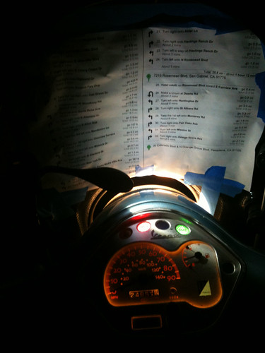
Taping a map to the scoot is still better much of the time — and WAY easier.
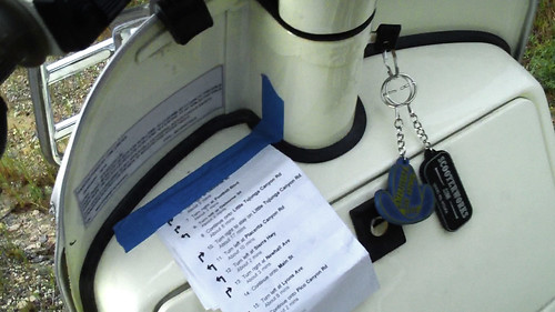
Deluxe lighted version
Eric // LA Scooter Meetup Group // Stella 4T // Vespa LX // Vespa LXS // Honda Helix // some, uh, projects…
-
PeteH
- Member
- Posts: 2281
- Joined: Mon Jan 17, 2011 4:32 pm
- Location: 3603mi SE of Dutch Harbor
GPS CoPilot seems to render proper turn-by-turn after drag-customizing a route. I'm not sure if it will try to snap back to the 'original' routing if you deviate while on the road.
Re: Garmins: yeah, I've got one, too, and unless you really have a top-of-the-line unit, preloading a route and waypoints is difficult to impossible.
I've truthfully only played with it in the car so far (as a passenger). I need to test the Bluetooth implementation a little further and see if it will play nicely with my Sena helmet rig. If I can get customized routing and good turn-by-turn in my helmet, I think I will have "arrived at my destination".
Feel da rhythm! Feel da rhyme! Get on up! It's Buddy Time!
-
Stilts

- Member
- Posts: 281
- Joined: Thu Jun 23, 2011 7:33 pm
- Location: Baltimore, MD
- Contact:
I totally agree. Printed directions along with a good paper map of the route stuffed in the glove box, for me nothing beats fostering a decent sense of direction and reading your directions before ever starting the bike. I find making my own route gives me some passing familiarity with the route that sticks in my head and I'm able to anticipate the next turn more easily.ericalm wrote:Will it then give you turn-by-turn based on the custom route?PeteH wrote:Just as an aside, I'm playing with the CoPilot GPS app (for iOS and Android). Unlike most 'mobile' GPS apps, you can drag a route to change it, as you would in Google Maps. Another slick feature is that you can select various vehicle types (car, RV, motorcycle, bicycle,...) and more importantly, you can tell the software to avoid or strictly-avoid certain types of roads (like Interstates), and you can specify the speed to use on each type of road in order to calculate drive time and choose routing.
If only Google Maps had this granularity of features!
I can't even begin to tell you the difficulties several friends in my riding group and I have had trying to get highly-customized routes into our GPS units (mostly Garmins). Drives me nuts.
Taping a map to the scoot is still better much of the time — and WAY easier.
Deluxe lighted version:

-
Stilts
- Member
- Posts: 281
- Joined: Thu Jun 23, 2011 7:33 pm
- Location: Baltimore, MD
- Contact:
I totally agree. Printed directions along with a good paper map of the route stuffed in the glove box, for me nothing beats fostering a decent sense of direction and reading your directions before ever starting the bike. I find making my own route gives me some passing familiarity with the route that sticks in my head and I'm able to anticipate the next turn more easily.ericalm wrote:Will it then give you turn-by-turn based on the custom route?PeteH wrote:Just as an aside, I'm playing with the CoPilot GPS app (for iOS and Android). Unlike most 'mobile' GPS apps, you can drag a route to change it, as you would in Google Maps. Another slick feature is that you can select various vehicle types (car, RV, motorcycle, bicycle,...) and more importantly, you can tell the software to avoid or strictly-avoid certain types of roads (like Interstates), and you can specify the speed to use on each type of road in order to calculate drive time and choose routing.
If only Google Maps had this granularity of features!
I can't even begin to tell you the difficulties several friends in my riding group and I have had trying to get highly-customized routes into our GPS units (mostly Garmins). Drives me nuts.
Taping a map to the scoot is still better much of the time — and WAY easier.
Deluxe lighted version
-
PeteH
- Member
- Posts: 2281
- Joined: Mon Jan 17, 2011 4:32 pm
- Location: 3603mi SE of Dutch Harbor
I agree - I have paper maps and printed turn directions as a backup, but I personally like exception-driven guidance rather than having to watch every intersection looking for the turn. In a perfect world, the odometer is accurate, but I somehow came up with a 10-mile discrepancy on a 100-mile ride when I compared my odo reading to a Google Maps route, so I remain a little pessimistic about looking for turns based on odometer readings (and I suck at doing decimal math in my head while trying to ride defensively).
Feel da rhythm! Feel da rhyme! Get on up! It's Buddy Time!
-
Stitch

- Member
- Posts: 509
- Joined: Tue Jun 12, 2012 6:12 pm
- Location: Port royal Pa
Awesome night version. I believe I may start using that.ericalm wrote:Will it then give you turn-by-turn based on the custom route?PeteH wrote:Just as an aside, I'm playing with the CoPilot GPS app (for iOS and Android). Unlike most 'mobile' GPS apps, you can drag a route to change it, as you would in Google Maps. Another slick feature is that you can select various vehicle types (car, RV, motorcycle, bicycle,...) and more importantly, you can tell the software to avoid or strictly-avoid certain types of roads (like Interstates), and you can specify the speed to use on each type of road in order to calculate drive time and choose routing.
If only Google Maps had this granularity of features!
I can't even begin to tell you the difficulties several friends in my riding group and I have had trying to get highly-customized routes into our GPS units (mostly Garmins). Drives me nuts.
Taping a map to the scoot is still better much of the time — and WAY easier.
Deluxe lighted version
"Stella" is Latin for "use threadlocker on all fasteners"
-
Rusty J
- Member
- Posts: 109
- Joined: Mon Apr 23, 2012 5:04 pm
- Location: L.A. Beach Cities, CA
More on CoPilot Live
Some quick comments after a bit of working with the app:
1. Apparently you can't extract saved routes from the IOS version (or load them from an outside source) unless you have a hacked phone with a file manager app -- Apple doesn't let you see the filesystem.
2. The *.trp file is not the route -- it's the instructions to the app for what needs to go into the route it calculates! It computes the route based on the *.trp file's waypoints, your chosen vehicle type, and your settings for that vehicle type. So, if you create the file on a tablet set for "automobile" and have "avoid freeways" set, load that *.trp file onto a phone that's set for motorcycle but have "neutral" for freeway preference under motorcycle, you may end up with a route that puts you on I-405 even though you're on a Stella. Pay attention to the details!
3. It WILL send you back to the starting point of a pre-planned route if the app closes (or you turn it off) during the trip. This is annoying, as it's awkward to delete waypoints you've already passed while you're moving. This is probably not unique to CPL, though.
4. (Android only) You can transfer saved POIs (favorites) also, but only as a single batch, and it'll overwrite the ones on the phone.
5. Even with all of the above, it's still quite useful.
-
PeteH
- Member
- Posts: 2281
- Joined: Mon Jan 17, 2011 4:32 pm
- Location: 3603mi SE of Dutch Harbor
I need to play with it some more.
My Sena Bluetooth is now working correctly with the iPhone, meaning that I'm getting the turn-by-turns in the helmet. That's a big step forward. I need to see if/how well routes can be planned on the iPad (easier to drag routes) then saved to iCloud then picked up on the phone. If that works at all.
My Sena Bluetooth is now working correctly with the iPhone, meaning that I'm getting the turn-by-turns in the helmet. That's a big step forward. I need to see if/how well routes can be planned on the iPad (easier to drag routes) then saved to iCloud then picked up on the phone. If that works at all.
Feel da rhythm! Feel da rhyme! Get on up! It's Buddy Time!
-
Rusty J
- Member
- Posts: 109
- Joined: Mon Apr 23, 2012 5:04 pm
- Location: L.A. Beach Cities, CA
If you can get this to work, please let us know.PeteH wrote:I need to play with it some more.
My Sena Bluetooth is now working correctly with the iPhone, meaning that I'm getting the turn-by-turns in the helmet. That's a big step forward. I need to see if/how well routes can be planned on the iPad (easier to drag routes) then saved to iCloud then picked up on the phone. If that works at all.
Thanks in advance!
-
PeteH
- Member
- Posts: 2281
- Joined: Mon Jan 17, 2011 4:32 pm
- Location: 3603mi SE of Dutch Harbor
Just an update - I've had some success with using RouteConverter (http://www.routeconverter.de) as a front-end to Google Maps to build up the route, then saving the .TRP file (waypoints), then passing the file to Copilot GPS on the iPhone using DiskAid (http://www.digidna.net). DiskAid let me stick the TRP file into the Apps / CoPilot / NA / Save folder, after which the iPhone app loaded it right up.
This technique would probably work to transfer a TRP file from the iPad version to the iPhone, using a laptop as the go-between, but it would be awfully nice if CoPilot supported DropBox or email transfers.
Again, all the above caveats about car vs. motorcycle mode, CoPilot recalculating route between waypoints, etc. apply. Using a lot of waypoints is probably a good idea to minimize the route deviations between. i'll clearly be doing some more playing here in the 'slow' season.
Feel da rhythm! Feel da rhyme! Get on up! It's Buddy Time!
-
Rusty J
- Member
- Posts: 109
- Joined: Mon Apr 23, 2012 5:04 pm
- Location: L.A. Beach Cities, CA
-
PeteH
- Member
- Posts: 2281
- Joined: Mon Jan 17, 2011 4:32 pm
- Location: 3603mi SE of Dutch Harbor
No jailbreaking required. In fact, you connect the iPhone to your computer first time with a USB cable, but after that, you can connect via Wi-Fi for the transfer. Handy!
I ran the on-demand-from-Web Java version of RouteConverter with no problems on Win7.
I ran the on-demand-from-Web Java version of RouteConverter with no problems on Win7.
Feel da rhythm! Feel da rhyme! Get on up! It's Buddy Time!